WEb Log
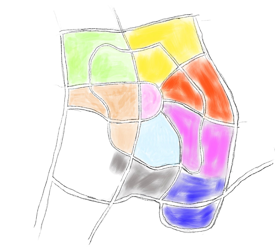
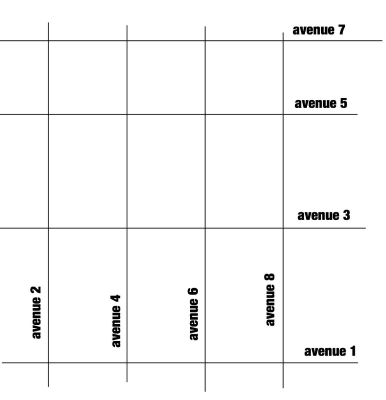
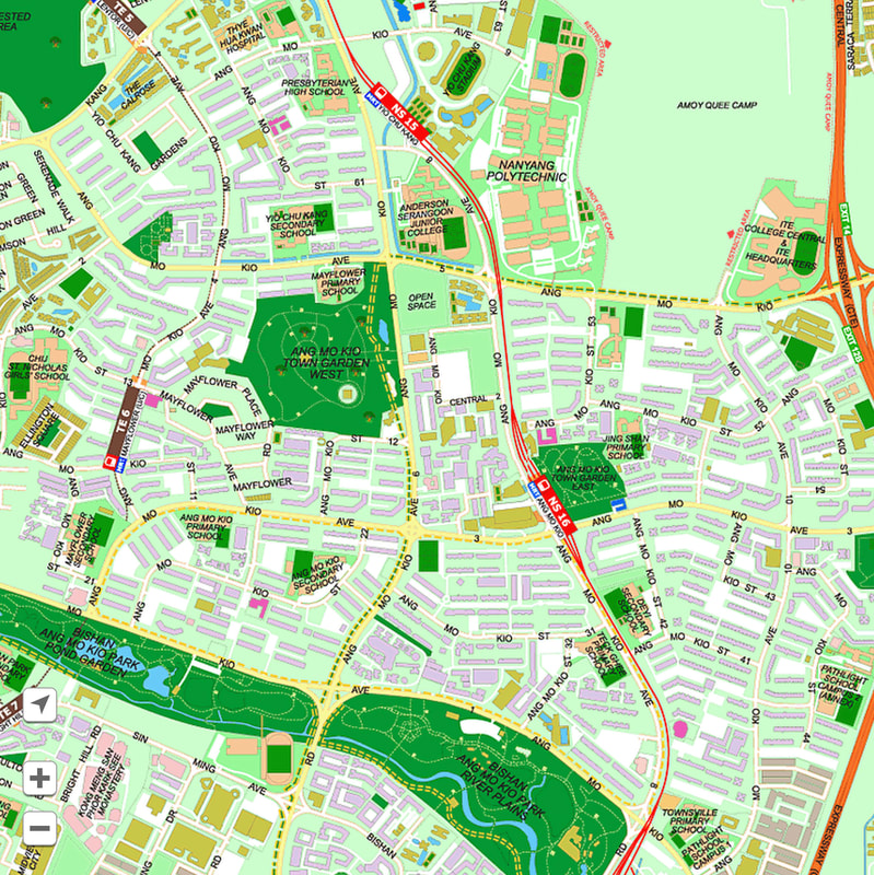
THE GENERAL KNOWLEDGE SERIES / HDB ROADSThe year 1990. I was 10 years old. I was waiting for the feeder bus service number 802 to go for my madrasah classes at Masjid Darul Makmur. While I waited for the bus, I saw a new thing on the bus stop notice board. It was very new. And I was excited. It was a map of Yishun showing bus routes. There were not much details. Just a road map. For as long as I can remember, I was obsessed with maps. I love maps very much. Remember there was no internet then. If I wanted to look at maps, I would have to go the library and look for atlas or globes. My father used to bring home planner books every year and there will be a map of the world in it. I would look at it and memorise the maps. That being said, there would only be maps of the world or maps of Asia. Anything smaller than that would be hard to find. But here, at the bus stop, there was a map of Yishun! How much smaller can it be? I kept looking at it in awe and memorised it. Every time I took a bus at the bus stop, I would look even more to remember more details to be memorised. I would then draw them on foolscap paper. I had a classmate. His name was Azmi. He was a sucker for maps too and we would compete with each other to draw the best looking maps. As accurate as possible, with as much details as possible. Here, I try to replicate the drawing that I did then when I first saw the map. I remember I quickly drew it in case it faded from my memory. Madrasah classes were easy to me at that time so I spent that day drawing this map. Before I would forget the details. Yishun New Town, as how it was called then, were separated into "Neighbourhoods". Each neighbourhood was colour coded. Neighbourhood 1 = Green Neighbourhood 2 = Yellow Neighbourhood 3 = Orange Neighbourhood 4 = Purple The mysterious Neighbourhood 5 = Dark blue. (It was a mystery then because that area was just forest. So I assumed that they were going to build flats there. They finally did after 2010) Neighbourhood 6 = Light blue Neighbourhood 7 = Brown (Yucks. I was annoyed that they used brown for my neighbourhood. I would love the pink.) Neighbourhood 8 = Grey Neighbourhood 9 = Pink The block numbers in the neighbourhood will start with that particular number. ie. Neighbourhood 1 = Block number 100 onwards. Neighbourhood 2 = block 200 onwards. Though not all neighbourhoods have a hundred blocks. And then as I observed the map, I realised a few patterns. Only when I was much older with accessible internet, then I would be able to prove it to people. At that time, when I told adults of my "discovery", they didn't believe me and they said it was just random order. Singapore's HDB estates are designed poorly. There are no straight lines with no explanations whatsoever. The roads curve randomly and without any good reason. The worse design to me would be Hougang. The neighbourhoods splatter everywhere. Tampines comes next. The minor roads lead to nowhere with random turns that would have saved space if they would just go straight. I have no explanation to the mess in the estate designs. It is disturbing to me but I still cannot find an explanation. Nevertheless, within this mess, there is this simple order that I realised. ONE. Street numbers. The street numbers are all assigned according to the neighbourhoods. For example, neighbourhood 1 will have streets such as Street 11, Street 12, Street 13, etc. Neighbourhood 2 will have street numbers such as Street 21, 22, 23 etc. Neighbourhood 3, Street 31, 32, 33, etc. TWO. Avenues. Pasir Ris uses "Drive" instead of "Avenues" but they are arranged the same way. When you study Geography, you will learn about "Latitudes" and "Longitudes". Latitudes are grid numbers going East to West while Longitudes are grid numbers going North to South. I realise the avenues are arranged in that way. Let's make it simpler with just "Horizontal" and "Vertical" lines. If you look at HDB maps, and you place "North" on top (supposedly quite naturally), Odd number avenues would be placed horizontally, while even number avenues would be arranged vertically. That is how it is supposed to be but like I said, I don't know why HDB estates are designed horrendously, therefore the roads are not straight horizontal or straight vertical. Ok so that is something I would like to share if it gives you some knowledge in this "GENERAL KNOWLEDGE" series! I remember sharing this to a girl in a school I taught. She was in Secondary 2 in a "clever school". And then she said to me, "how is that a good information and beneficial to anyone when we all use GPS now?" I was a bit sad. But she was from a clever school while I was from a neighbourhood school in Yishun neighbourhood 1, so I guess she should be cleverer than me. I didn't say that we didn't have GPS in 1990 so I guess I am irrelevant. Well maybe if you are a map geek like me, you would enjoy this info! But then again if you're a map geek, you would have already know this. Ok then.... it was fun to me at least. "don't just share celebrity posts because they are good looking they already have a lot of followers and sponsors your friends would have seen them even before you share them like a post because of the effort creating them share a post to allow others to enjoy them thank you for reading"
0 Comments
Leave a Reply. |
HelloWeb logs of art activities on a regular basis (hope). Archives
June 2024
Categories
All
|
Proudly powered by Weebly


 RSS Feed